Lake Charlevoix
Zhiingwaak Ziibiing
Description and Background
Lake Charlevoix is a connecting water to Lake Michigan with two basins. It is the third largest lake in Michigan with a surface area of 17, 265 acres. Lake Charlevoix flows into Round Lake and into the Pine River and drains into Lake Michigan. Lake Charlevoix has nine tributaries that flow into it. 75% of the discharge into Lake Charlevoix is contributed to the Jordan River and the Boyne River. The deepest point in Lake Charlevoix is located in the main basin at approximately 37 meters. The Lake Charlevoix watershed encompasses over 335 square miles. Three main cities border the lake. These cities are Charlevoix bordering the northwest corner of the north arm, Boyne City bordering the southeast corner of the north arm, and East Jordan in the South Arm.
The majority of land cover surrounding the Lake Charlevoix shoreline is urban and built up for seasonal residential housing. Impacts on the Lake Charlevoix Watershed can be traced back to the 1800’s when lumbering industries bordered the Lake Charlevoix shoreline. Potential impacts of the present time include but are not limited to: a discharge pipe for treated wastewater from Boyne City on the main basin, residential shoreline nutrient runoff, and sediment runoff at road accesses.
LTBB is a partner on the approved Lake Charlevoix Watershed Plan and represents the Tribe on the Lake Charlevoix Steering Committee. Lake Charlevoix is a lake that has been identified as a lake used by Tribal Citizens for fishing, cultural/ceremonial, boating and swimming.
The Tribe has two monitoring sites on Lake Charlevoix, one per basin. The south arm, site CXL1, is smaller in volume and monitoring is completed in one of the deeper areas of the basin at 36 feet. The main basin, site CXL2 is larger in volume, connects to Round Lake, and its sampling is completed at a depth of 99 feet.
Tribal Uses and Attainment
The primary Tribal use on Lake Charlevoix (CXL) is CF. Oher Tribal uses applied are SF IAW, NU and PC (May through October). All uses are supported at Lake Charlevoix including SF. The Great Lakes Fisheries Program (GLFP) in collaboration with the WQPP has done some preliminary research on fish tissue and methyl mercury concentrations therefore SF is given full support as well as given the need for further evaluation on the amount of fish eaten by subsistence families and types of fish. Methyl mercury concentrations were the lowest of the five lakes monitored in 2012.
LEGEND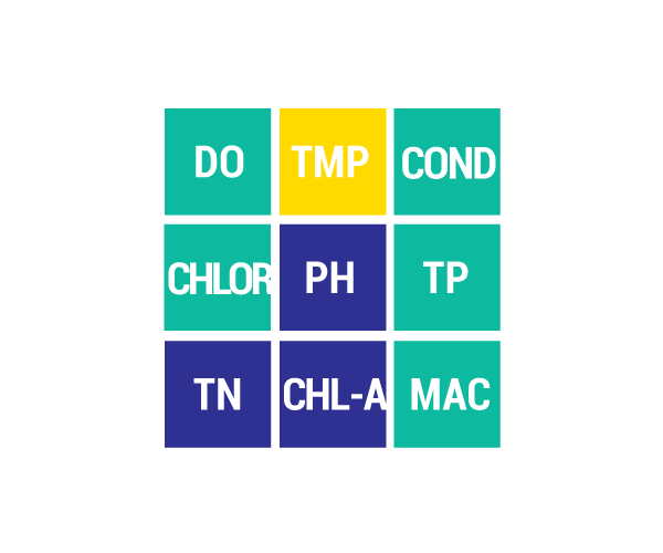
DO Dissolved Oxygen
Respiration for fish, other aquatic organisms
TEMP Temperature
General aquatic life support and reproduction
COND Conductivity
General aquatic life support, dissolved solids indicator
CHLOR Chlorides
General life support, salinity indicator, drinking water pollutant
PH Potential Hydrogen Ion Concentration
Acidity/alkalinity indicator, drinking water pollutant
TP Total Phosphorous
Major algae nutrient, fertilizer/manure runoff indicator
TN Total Nitrogen
Major algae nutrient, drinking water pollutant, fertilizer/manure runoff indicator
CHL-A Chlorophyll-a
Algae concentration indicator
HAB Habitat
Instream and riparian structure to support life cycles of fish and other organisms
MAC Macroinvertebrates
Indicator of water quality based on the diversity of pollution tolerant and intolerant
aquatic insects and non-insects that are visible to the naked eye and do not have a backbone
TSS Total Suspended Solids
Indicator of aquatic life support, oxygen levels
FQA Floristic Quality Assessments
Indicates quality of wetland based on the plant community present
CONDITION INDICATORS
Poor Fair Good Very Good