General Election: June 28, 2021 Candidates for Tribal Council
RICKY COMPO
TAMARA KIOGIMA
LEROY SHOMIN
DOUG EMERY
WILLIAM ORTIZ
MARCI REYES
KENNETH DEWEY
AARON OTTO
SHARON SIERZPUTOWSKI
SIERRA BODA (WITHDREW 5-14-21)
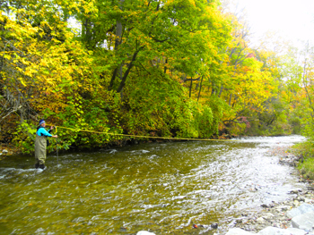
The Bear River is the largest river in length that LTBB monitors and is the largest tributary in the Little Traverse Bay Watershed. The Bear River is approximately 14.6 miles long. The Bear River originates at Walloon Lake and flows into Little Traverse Bay. Springbrook Creek, an established trout stream, is a confluence to the upper stretch of the river. The last mile of the Bear River runs through the City of Petoskey and contains the steepest drop of any river in Michigan’s Lower Peninsula. The geographical area was formed by glaciers and beneath the river are large limestone beds.
The City of Petoskey, where the mouth of the river flows into Little Traverse Bay, was once named “Bear River”. The Odawa Tribes historically utilized the river and surrounding land area for fishing, gathering medicines, food, and fruits, and hunting and continue to do so today. The Bear River received its name based on the historical population of bears living near the river. The Odawa people used to hunt bear throughout the river’s land base. Residents of the City of Petoskey relied heavily on the Bear River for industry and energy purposes. There were once seven dams on the river, providing power to grist and lumber mills and supplying the city and the surrounding community with electricity.
There are three sites monitored on the Bear River. The downstream site, BR1, is near the mouth of the river and upstream from the old hydroelectric dam. This dam now serves as a lamprey control structure. BR4 is the upstream site and is located approximately 65 feet downstream of Walloon Lake. BR3A is downstream of BR4 and after the confluence of Springbrook Creek. BR3A is located at a moderately to heavy used road bridge crossing.
The following Tribal uses are applied to the Bear River: IAW, CF, SF, TCCU, and PC (during May through October). The primary use at all sites is CF. All Tribal uses are supported based on LTBB data results. Subsistence fishing is deemed as needing further evaluation based on a lack of toxin data in fish and data on how much fish Tribal families eat for subsistence.
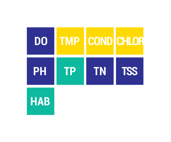
DO Dissolved Oxygen
Respiration for fish, other aquatic organisms
TEMP Temperature
General aquatic life support and reproduction
COND Conductivity
General aquatic life support, dissolved solids indicator
CHLOR Chlorides
General life support, salinity indicator, drinking water pollutant
PH Potential Hydrogen Ion Concentration
Acidity/alkalinity indicator, drinking water pollutant
TP Total Phosphorous
Major algae nutrient, fertilizer/manure runoff indicator
TN Total Nitrogen
Major algae nutrient, drinking water pollutant, fertilizer/manure runoff indicator
CHL-A Chlorophyll-a
Algae concentration indicator
HAB Habitat
Instream and riparian structure to support life cycles of fish and other organisms
MAC Macroinvertebrates
Indicator of water quality based on the diversity of pollution tolerant and intolerant
aquatic insects and non-insects that are visible to the naked eye and do not have a backbone
TSS Total Suspended Solids
Indicator of aquatic life support, oxygen levels
FQA Floristic Quality Assessments
Indicates quality of wetland based on the plant community present
Poor Fair Good Very Good
RICKY COMPO
TAMARA KIOGIMA
LEROY SHOMIN
DOUG EMERY
WILLIAM ORTIZ
MARCI REYES
KENNETH DEWEY
AARON OTTO
SHARON SIERZPUTOWSKI
SIERRA BODA (WITHDREW 5-14-21)
BERNADECE (BERNIE) BODA & LINDA GOKEE
REGINA GASCO-BENTLEY & STELLA KAY
(Click Team To Read Their Statements)
BERNADECE (BERNIE) BODA & LINDA GOKEE
REGINA GASCO-BENTLEY & STELLA KAY
(Click Candidate Name To View Their Statement)
Search Code Index
function search(string){ window.find(string); }
LTBB Events
Sun Mon Tue Wed Thu Fri Sat Subscribe to filtered calendar
Contact SPRING
[ninja_form id=12]
https://app.hellosign.com/s/LJki90VA