Spirit (Wycamp) Lake
Mnido Zaagigan

Description and Background
Spirit Lake is a shallow lake located in Bliss Township with a small section of the east side in Cross Village Township in Northern Emmet County. It is 610 acres in size. The area surrounding Spirit Lake is primarily forested and forested wetland. The majority of the land that surrounds Spirit Lake is owned by the State of Michigan with approximately 200 acres owned by a private land owner. Over 400 acres of the land surrounding Spirit Lake is used as a private hunting preserve.
The two townships Spirit Lake encompasses have a large population of LTBB citizens. The lake and adjacent grounds are used for ceremonies, hunting, fishing, and gathering by the Odawa people. Natural resources are gathered for food, ceremonies, art and crafts, and medicinal practices. The lake area was and still may be used as a meeting place for Odawa elder gatherings. A historical & cultural land use report was completed on July 25, 2006 by Wes Andrews. This report includes an inventory of historical information, cultural resources, and recommendations for the management of Spirit Lake. According to a Tribal use questionnaire given to community members at a 2008 annual community meeting, Spirit Lake is the third most used lake out of lakes monitored by the LTBB water quality monitoring program. It had the highest rank for cultural/ceremonial use by Tribal citizens.
The historical community encompassing Spirit Lake known as Wycamp Creek Village is eligible to be listed in the National Register of Historical Places due to the cultural resources it provides. This area and the outlet, Wycamp Creek was used as part of a sawmill operation years ago, known as the Wycamp Sawmill.
The LTBB NRD has written a management plan for Spirit Lake. As quoted in the Wycamp Management Plan, “The goals of the Natural Resource Department are to manage fisheries and wildlife populations for the benefit of Tribal members for the next seven generations. With this in mind, the Tribe will make recommendations on management that will help protect the natural resources of Spirit Lake. The overall goal of this lake plan is to apply an ecosystem management system approach that recognizes the interrelated nature of air, land, water and all life. This watershed approach is intended to include the whole system and focus on the interrelationships of the lake environment and the biotic communities.”
Management issues in the past have been related to water quantity versus water quality. Water levels and dam control have been a concern in the past to LTBB citizens and the surrounding community. In 1960, a court-ordered water level was instated on Spirit Lake. The water level should be no more than 611.0 feet above mean sea level in winter and 611.8 feet above mean sea level in summer (Jansma, 1960). LTBB NRD has put at least one staff gage at the dam in the lake to monitor the lake level. This staff gauge allows LTBB NRD Inland Fisheries and Wildlife (IFW) to monitor water fluctuations and the effects on aquatic life, fish, wildlife and wild rice growth.
There is only one monitoring site on Spirit Lake.
LEGEND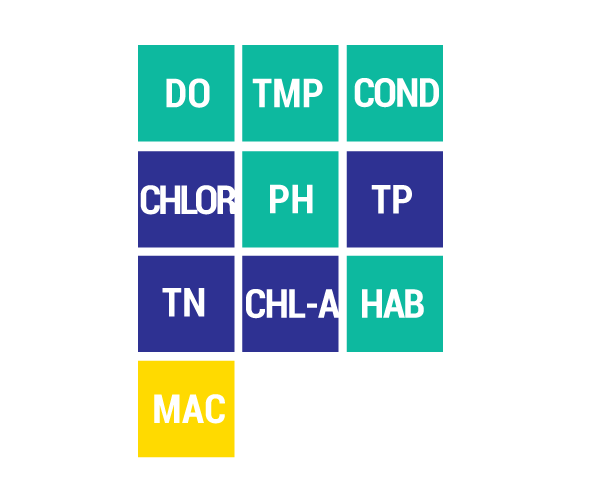
DO Dissolved Oxygen
Respiration for fish, other aquatic organisms
TEMP Temperature
General aquatic life support and reproduction
COND Conductivity
General aquatic life support, dissolved solids indicator
CHLOR Chlorides
General life support, salinity indicator, drinking water pollutant
PH Potential Hydrogen Ion Concentration
Acidity/alkalinity indicator, drinking water pollutant
TP Total Phosphorous
Major algae nutrient, fertilizer/manure runoff indicator
TN Total Nitrogen
Major algae nutrient, drinking water pollutant, fertilizer/manure runoff indicator
CHL-A Chlorophyll-a
Algae concentration indicator
HAB Habitat
Instream and riparian structure to support life cycles of fish and other organisms
MAC Macroinvertebrates
Indicator of water quality based on the diversity of pollution tolerant and intolerant
aquatic insects and non-insects that are visible to the naked eye and do not have a backbone
TSS Total Suspended Solids
Indicator of aquatic life support, oxygen levels
FQA Floristic Quality Assessments
Indicates quality of wetland based on the plant community present