Larks Lake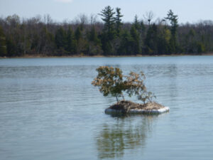
Description and Background
Larks Lake is a shallow spring-fed marl lake with a surface area of 592 acres. The Larks Lake watershed is a small watershed with a land surface area of 4,640 acres. The Larks Lake watershed is a sub watershed of the larger Cheboygan River Watershed. The Cheboygan River Watershed covers 1,461 square miles. Larks Lake drains into Brush Creek which meanders through Pleasantview Swamp. Within the Pleasantview Swamp are four “spring ponds” (called The Four Lakes) that form the headwaters of the Maple River.
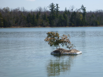
Larks Lake has been seeded with wild rice by the LTBB Inland Fisheries and Wildlife program annually from 2009-2014. With the help of the LTBB WQPP and Youth Conservation Corps, the planting area has been refined and there was about an acre of wild rice growing in the northwest corner of the lake in 2014. Although the rice was later eaten by what we assume were geese, the lake is expected to continue producing wild rice.
Land cover surrounding the lake is seasonal and/or year round residential housing. There is a county park area with a sandy beach, a public access and boat launch area, with a predominate area of land consisting of forested lowland and wetland. In the 1900’s, there was a saw mill operation adjacent to Larks Lake and a dam at the headwaters of Brush Creek. According to the local community the dam was taken out approximately 40 years ago. Historical information was provided by local individuals attending the first meeting in accordance to the creation of the Larks Lake Watershed Plan.
There is one site monitored by LTBB on Larks Lake, near Pioneer Picnic Park.
Tribal Uses and Attainment
The primary Tribal use on Larks Lake (LSL) is WF. Oher Tribal uses applied are IAW, WRA and PC (potential of cercarial dermatitis to occur in this lake). All uses are supported on Larks Lake for this reporting period.
LEGEND
DO Dissolved Oxygen
Respiration for fish, other aquatic organisms
TEMP Temperature
General aquatic life support and reproduction
COND Conductivity
General aquatic life support, dissolved solids indicator
CHLOR Chlorides
General life support, salinity indicator, drinking water pollutant
PH Potential Hydrogen Ion Concentration
Acidity/alkalinity indicator, drinking water pollutant
TP Total Phosphorous
Major algae nutrient, fertilizer/manure runoff indicator
TN Total Nitrogen
Major algae nutrient, drinking water pollutant, fertilizer/manure runoff indicator
CHL-A Chlorophyll-a
Algae concentration indicator
HAB Habitat
Instream and riparian structure to support life cycles of fish and other organisms
MAC Macroinvertebrates
Indicator of water quality based on the diversity of pollution tolerant and intolerant
aquatic insects and non-insects that are visible to the naked eye and do not have a backbone
TSS Total Suspended Solids
Indicator of aquatic life support, oxygen levels
FQA Floristic Quality Assessments
Indicates quality of wetland based on the plant community present
CONDITION INDICATORS
Poor Fair Good Very Good